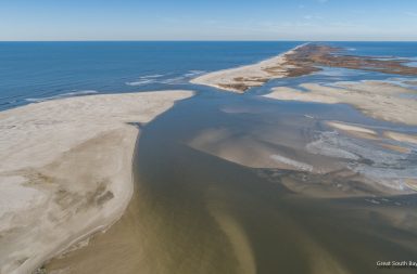
Now let us look at how the breach itself has changed since January 2017. The monthly aerial oblique photos and photo mosaics are shown on the project website while those from January 2017, January 2018 and October 2018 are shown in Figures 2-4. In these photos it is pretty clear that the overall size of the breach has not changed all that much. But what has changed is the channel through the flood delta – the area north of the breach – which effectively controls the conveyance of waters between Bay and ocean. In January 2017, while the eastern shoreline had intruded into the breach and there was a sand shoal to the north, there still was a single channel that swept along the western shoreline then south of the remains of Pelican Island and up to the northwest pretty well through the flood delta. By January 2018 there were several more shoals within the former channel and even though the shoreline on the eastern side had receded, the pathway into the Bay was clearly more convoluted and restricted. And the channel through the flood delta to the northwest had acquired shoals that were not there a year previous. The latest picture from October 19, 2018 in Figure 4 shows that the eastern shore has again pushed while the conveyance channels have become even more obstructed. This aerial time series clearly suggests that the pathway through the breach and into Bellport Bay has gotten smaller and less efficient. And when the flow slows down because of obstructions and bottom friction, it loses some of its ability to keep sand in suspension and deposition begins to out strip erosion. That is the prescription for closing of a breach.

January 15, 2017

January 15, 2017

January 15, 2017
Continued on Page 3