Reprinted with permission from Dr. Flagg
Charles Flagg / School of Marine and Atmospheric Sciences, Stony Brook University
This is a quick update on the status of the breach prior to the nor’easter that’s predicted for Friday and Saturday (Mar 2-3, 2018).
The fall of 2017 was pretty active in terms of windy weather, waves, flooding and changes in the breach. The waves from hurricane Jose in September knocked down many of the shoals in the breach which were then built up again over the next month. As a result, the October 20 overflight showed a re-establishment of the through-breach shoal with more sand for the shoal to the east of the remnants of Pelican Island.

Photo Mosaic of the breach and flood and ebb deltas October 20, 2018 | Mark Lang

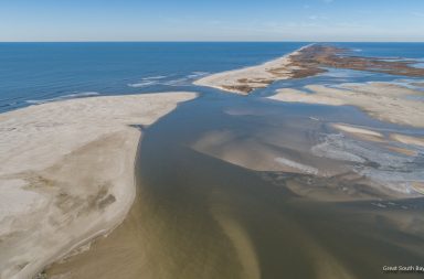
October 20, 2017 | Dr. Flagg
We had a substantial flooding event of October 29-30, amazingly on the precise 5th anniversary of Super Storm Sandy. Local maximum winds for that event were out of the southeast at 30 to 40 kts producing high water at the Bellport Dock slightly more than 1 meter above mean water level. Since then, we have had a series of high wind conditions out of the west on November 10,17 and 20 which raised water levels at the Bellport end of the Great South Bay by as much as 0.5 meters at one point.
All these high waters and wind-waves should have reworked both the breach and the shoals. So I was surprised to find on the November 28th flight that conditions appeared rather as they had been before the November Storms.

Oblique aerial photo of the breach and flood delta from the northeast November 28, 2017 | Dr. Flagg

November 28 2017 | Dr. Flagg
Continued on Page 2