By Mike Busch
With three consecutive Nor’easters fresh in the memory, I wanted to look back at another huge March Nor’easter back in 2010. It is hard to remember these storms but this was one of the strongest and destructive storms to hit our area after Sandy and the Perfect Storm of 1991. Local impacts included massive erosion on Fire Island and Ocean Parkway with winds gusting to Hurricane Force at Kennedy Airport and over 60 mph at Islip.
You can read more about this storm in a summary provided by the National Weather Service.
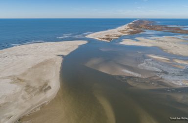
My only memory was an incredible Blow Out tide that I witnessed on Bellport Bay. Blow out tides are the opposite of storm surge, where wind can push the water out to sea or away from shore. In this case, I suspect the East wind pushed the water toward the Western Great South Bay.
The photos below were taken in Bellport and Brookhaven at the height of the storm on March 13, 2010. The exposed bottom at Bellport Marina in many of the photos below is something I have never seen before. On page 2, you can see that the bay receded several hundred yards from the shore in Brookhaven, it looked like you could walk across the entire bay from there. You will also see Beaver Dam Creek nearly empty and old docks exposed that hadn’t been seen in years.
I apologize for the quality of the videos and photos, I wasn’t much a photographer at that point.

Bellport Marina

Looking West from Bellport Dock

Howell’s Point

Bellport Dock


More Images on Page 2