Reprinted with Permission from Dr. Charles Flagg
Charles Flagg / School of Marine and Atmospheric Sciences, Stony Brook University
This is a quick note on the status of the breach after the series of nor’easters we have had over the past month and a half. In the past the nor’easters often opened up the breach and the channel to the Bay but that doesn’t seem to have happened of late.
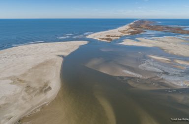
Figure 1 shows the photo mosaic from the end of February before the nor’easter onslaught.

Figure 1, Photo mosaic of the breach from the February 27,
2018 overflight at 09:15 EST. Mark Lang
At that time the breach area was characterized by numerous shoals in the offshore area, many of which were dry during low tide. The offshore shoals to the west marked out a prominent and deep feature called a marginal bypass channel. The shoals in the middle of the breach were broad but did not dry out at low tide while many of those in the flood delta area, did.

Figure 2, Photo mosaic from the March 26, 2018 overflight at 08:45 EDT Mark Lang
By the end of March after four of the nor’easters came through, the main change was the growth of the eastern shoal in the breach itself. This is not all that obvious from the mosaic but is clearly visible in the oblique photo in Figure 3. The growth of this eastern shoal resulted from from the coalescence of as series of ephemeral shoals through the breach that began to appear in July. The storms seem to have spread the sand out as well as adding more sand to the area. If this shoal persists and permanently connect to the eastern shore, it will significantly add to the shoreline and constrain the main channel to the west. Another significant change has been the erosion of the series of alongshore shoals along the western shore although one of those shoals just south of the breach still came above water at low tide. Lastly, several of the shoals in the flood delta came dry at low tide. Although the March flight took place just below mid-tide, the water level in the Bay was not that low, so only the “New Ridge” island in the center-right in the photo was dry at this tide stage. It would seem that the series of storms, not all of which produced high winds, smoothed out some of the flood delta shoals. Ultimately, that is what we can expect to happen to the flood delta and the old “flats” will be re-established although shallower than before Sandy.

Figure 3, Oblique aerial photo of the breach taken on March 26, 2018.
A recent high altitude oblique photo from April 21st in Figure 4 shows the breach area near low tide and clearly shows the shoaling that has taken place over the past couple of months. The shoal extending out from the eastern shore visible in the previous two months has grown. The darker coloring indicates that it is covered during high tide and so does not quite represent an extension of the eastern shore into the breach. But its effect on the main channel is clear as the channel is squeezed further. This photo also reveals how complicated the channeling into the flood delta area is which now splits around the remnants of Pelican Island and crosses several more shoals to the east.

Figure 4, Oblique photo of the breach area taken on April 21, 2018
Another overflight took place on April 26th but it was taken near high tide and does not show much more than the photo in Figure 4. (Posted on the project website.)
We all know that the breach will eventually close if left to its own devices. It has been open now for about 5 ½ years. Based upon the developments over the past few months with the growth of the eastern shore-shoal and increasing dendritic nature of the channels into the Bay, I think we are clearly heading toward closure, and sooner rather than later. In the past, the nor’easters have been able to clear out the channels but that has not happened during the recent storms. In fact the storms seem to be depositing more sand. As the channels are squeezed, the frictional drag on the water increases, the currents slow and the sand that used to stay suspended in the water column is being deposited in the main channels. If these conditions continue theprognosis for breach closure is clear. When, is still hard to say.
For prior reports and access to full size images, please visit Dr. Flagg’s site at SOMAS and his Great South Bay project website.
Did you know that there are three live cameras broadcasting from Davis Park, Fire Island?
Click below for live views from the Marina, Beach and Surf Cams: