By Mike Busch
March 2018 will not soon be forgotten from a weather perspective, with four Noreaster’s bringing a variety of wild weather conditions. All four storms were classic Coastal storms with Northeast winds and rapidly deepening pressure as they passed near the 40/70 Benchmark. While all four storms were strong, the first storm that impacted our area on March 2 and 3rd had the biggest coastal impact. The storm hit at the time of astronomical high tides and moved slowly enough to impact multiple tide cycles. Many people were surprised that the water levels remained elevated well after the storm passed.
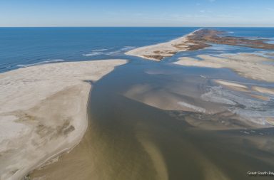
On March 6th, water levels were and surf were still high as we waited for Noreaster # 2 to arrive the next day. I never had a chance to post these images or footage but now that the weather has calmed down I finally got a chance to go through them. Normally after a storm you would expect the water to be churned up and dirty but the ocean was spectacular with some of the cleanest water I can remember. In the video and drone images on page 2 you can see multiple areas where the surf washed over into the bay.


Drone Images on Page 2